Gravel Cycling in Ontario
Great Routes in the Almaguin Highlands
Whether staying with us, already planning a trip to the region or looking for inspiration on great gravel cycling opportunities in Ontario, we have put together this page as a resource to help you prepare. In addition, we have included a selection of our favourite routes from the region. They include gravel, road and bikepacking options.
We hope this page inspires your to get out and explore!
If you find this page useful, we welcome it being shared with your two-wheeled community: www.mlat.ca/gravel-cycling-in-ontario-routes-in-almaguin-highlands
Jump to: Getting ready to ride
Jump to: Route Information
Introducing the Riding in Our Region
The secret cheat code to a great Ontario gravel cycling getaway? Stay with us!
We are big fans of the great riding available in the Almaguin Highlands. The scenic gravel roads are why we picked this region to establish Missing Link Adventure Tours. We bring together route design, accommodation and activity-enabling meals to support great days of riding and discovering the region. For our cycling guests, we provide route planning informed by their distance and surface type preference as well as fitness and experience level.
A base route design that we can personalize
We typically have a design plan based on the intentions of the weekend. This might include casual touring, training and skill development or finding the fastest way to the beach, coffee or buttertart. Routes consider total distances and distances between stops based on rider experience, fitness and stated goals.
Routes will feature local landmarks, like Screaming Heads or the many incredible natural views. Rides often feature a stop alongside a lake, river or waterfall. Checking out a piece of local history or saying hi to a local artist at their studio are also options. We wrap the day up with a celebratory meals and big shared table. Our co-located organic veggie farm and detailed menu planning helps fuel great weekends of riding.
What makes for great riding can make logistics a challenge
The remote and quiet roads are a highlight of the region’s riding. Being remote and accessing them can present some logistical challenges. On some routes, we setup a remote water and feed station to support discovering some of the more remote gems. If planning your own stay and ride, do your homework! If referencing information online sure you have an understanding of the terrain, surface type and condition and hydration and refueling opportunities.
You can check out our cycling retreat and getaway options here. We have a range of options all centered around a few days dedicated to riding, sharing great meals and discovering a beautiful part of Ontario.
Whether you are staying with us, looking for a great place to visit and go riding or already have a stay planned out, we want to provide some details to help make for some great time on the bike.
As always, follow the rules of the road, plan ahead and work within your experience and abilities.
What do we mean by ‘the Region’?
Missing Link Adventure Tours is centrally located in the Almaguin Highlands. We are lucky to live in and get to ride around a huge chunk of Ontario, with routes that connect the western edge of Algonquin Park east to Georgian Bay and from Huntsville and the northern edge of Muskoka up to the bottom of Lake Nipissing and North Bay. The broader region is Parry Sound District and includes Parry Sound, Loring-Restoule and the many villages of the Almaguin Highlands, including Burk’s Falls, Kearney, Sundridge, South River and Magnetawan, to name just a few.
What types of riding do you have? (Disciplines)
The terrain, roads and trails in our region support 4 types of riding, which we briefly describe here. If you are checking out our website you might think we only have gravel. Not so, but we do believe we have access to the best gravel cycling experience in Ontario.
(we can hear the ruffled feathers from here….)
Gravel – the best gravel cycling experience in Ontario
Woah!? Explain yourself!
Scenic, remote, well maintained ‘champagne gravel’ routes, with options for some touches of ‘spice’ if desired and that are downright entertaining to ride...over multiple days with fresh routes each day. It is why we are based here.
You want more evidence?
- When the road riding crew from Parry Sound, or the mountain bike crew from Muskoka need their gravel fix, they come to the Almaguin Highlands.
- The HMBA’s fundraising Gravel Grinder and the Parry Sound Bikes & Trestle Brewery ‘Off the rails gravel party’ fun ride both make use of routes in the core of Almaguin Highlands.
- Our co-host for Gravel Camp, Adam Hill (a 30,000km a year rider) claims his best rides of the year were during his stay with us.
Are there great gravel cycling events and rides across the province? Absolutely. We always promote the ‘love where you ride’ motto, but when it comes to putting together multiple days of riding on fresh roads tailored to your personal tastes, the Almaguin Highlands simply serves it up (and we love cooking with these ingredients)!
Gravel Riding Teaser Photos


Road Riding
Locally, ‘Almaguin In Motion’ is an informal group that plans rides focusing on paved routes. Start points and routes move around the region. On the Georgian Bay side, Parry Sound Bikes has a significant in season road riding group that has grown to the point of being spread over multiple nights.
Road Riding Teaser Photos


Bikepacking
When designing a bikepacking route, we often prefer the quieter gravel roads with adjustments made to support linking together overnight destinations, resupply and the appropriate level of spice. Route can come in 'gravel' and 'adventure trail' flavours and take in some beautiful and remote areas.
Bikepacking - Photos from our Intro Bikepacking Weekends


‘Adventure Trail’
Not to be confused with single-track mountain biking, adventure trail scenarios appear when the route gets incredibly rugged. Taking on an adventure trail isn’t about fast and flowy, it is about facing the unpolished terrain and going places that very few people let alone cyclists go. Forestry roads, ATV trails and abandoned roadbeds. The fat bike is often the bike of choice to manage soft, cobbled and variable conditions. If you follow Rob on social media or Strava, you will see the odd adventure trail ride, often with no route information included, as things can get a little spicy. We don’t include these trails in our regular gravel retreats, but can build some spicy adventures for custom getaways.
Adventure Trail Teaser Photos


What about Mountain Biking?
We want to support our guests and visitors to the region in finding the riding suited to their preferences. Rob grew up mountain biking around Huntsville which fostered the love of two-wheeled fun that has lead to the creation of Missing Link Adventure Tours.
When it comes to pure mountain biking, we are surrounded by great shops, community organizations and dedicated riding centers. A mountain bike is a valid option for riding gravel roads and dabbling in some local trails, but for purpose built flowing and technical trails in the region, check out the following links:
Georgian Nordic Activity Center (West - Parry Sound area)
North Bay Mountain Bike Association (North)
Huntsville Mountain Bike Association (South – Huntsville area)
Muskoka Off-Road Cycling Association (South – Bracebridge area)
Getting ready to ride
Plan for your ride, not just your route:
Ride planing is more than where you are going to go. Various factors might inform adjusting your usual distance or what you pack with you. Who you are riding with or creating a ride plan for is a major consideration. A little bit of ‘adventure’ and surprise can make for a memorable day, but some simple steps can help keep a challenging ride in the realm of a great ride.
Routes Appropriate for Everyone
We love the “So, Thomas wanted to try a new route...” rite of passage in cycling (names possibly changed to protect the innocent ;-)) and in terms of the route ecosystem, a bit of adventure often leads to finding routes that can be gems with a bit of polish. That said, as a local, we can mix in a little bit of ‘try’ every so often. If in the area for a few days and on precious vacation time, plan for a great day on the bike FOR EVERYONE you are riding with.
Route and re-route options:
When guests join a gravel cycling weekend, we typically have a base route planned and then make adjustments. Revisions can be for the group or individual guests. Attention goes into designing a weekend of riding to minimize repeating sections of the route. What we love about the region is how easy many routes can be adjusted to dial in the desired distance.
That said, a few routes, like the South Section of Nipissing Road have large uninterpreted sections, which mean limited options for adjustment. If you are used to a grid of concession roads ever few kms and short-cuts back home (looking at you, Southern Ontario folks), make sure you study your route to know your options (or lack thereof) for making adjustments.
Check cell service coverage - gravel cycling routes are typically more remote
Plan ahead, the more remote you are planning to be, the more effort should go into confirming cell phone coverage. Your provider likely has an online coverage map. Towards Algonquin Park and into the park away from the Hwy 60 corridor and along the south side of Lake Nipissing might have pockets without service. (Planhub.ca coverage map - external link) and variations between carriers can be significant. While service can be spotty in places, it hasn't presented as a material issue in our experience. Likely more relevant is simply ensuring your phone is fully charged before heading out and your battery life can manage any peripheral usage such as riding tracking etc.
Monitoring the weather & environmental conditions
Wind storms and heavy rain events can and have caused serious road damage in and around our region in recent years. As riders and farmers, weather radar is our most watched show. As residents, we have the flexibility to adjust routes based on local intel and recent weather.
If you are planning to visit area, check on weather and reports at least two weeks prior, as this is the window where road and tree damage is typically repaired. Check in with your accommodation provider or check municipality websites for any road information.
Keep in mind that forecasts are regionally based. For example, the EC forecast for Burk's Falls is based on the Muskoka Airport, 80km south.
In addition to checking forecasts, reference radar for your route. Radar can clarify if forecast weather is passing through or outside of the planned area. Keeping tabs on radar can help adjust for the regional differences in forecast locations. Check the forecast -- verify with radar. (Environment Canada Radar - Burk's Falls, ON)
Sun and the Seasons
If road riding, many of our quieter secondary highways run east-west. Early and late season riding can result in prolonged sunsets which impact visibility for road users. Considering where the sun will be and planning for or changing a route direction (e.g. CW vs CCW) will change the side of the road you are on and can move you away from the direction of traffic where sunset may impact vision. Gravel routes are typically more treed, have less traffic and shorter sight lines, reducing the frequency and severity of sun impacting road users.
Traffic Considerations
We have mentioned that Rob grew up riding the trails and roads around Huntsville and Muskoka. The scenery and rugged terrain makes every ride memorable. Put simply, the traffic north of Novar, once off the Hwy 11 corridor and the secondary highways that link the villages of Almaguin, is much less than Muskoka.
Unsurprisingly, long weekends have more traffic, including more camper/RV/pulling trailer traffic, but typically peak the evening leading in and then the afternoon at the end. When approaching a town core or local hub (Provincial Park etc.) considering shifting off the main route to a parallel and quieter option where available.
GPS with Route Information Independent of Cell Service
If doing any remote exploring, consider having a GPX file on a true GPS enabled device and knowing what other seasonal activities are happening in the region. Any "?" popping up in route planning should be offset with contingency planning.
If planning your own routes, heat maps can be useful, but review the route and use some caution as the base data may be from users across various modes of travel, such as snowmobiles. It can be a hard lesson to learn that snowmobile trails of use wetlands and waterways. Routes that utilize named municipal roads are generally a good place to start until you are familiar with the region.
Vitamin G1 and G2 – we LOVE the stuff:
You weren’t expecting a page about gravel cycling to turn down ‘Health Influencer’ Lane, were you? Good, because this isn’t that!
Vitamin G1 – Gravity
You can’t escape a dose of gravity and elevation riding in this area. Expect 100m climbing per 10KM as starting point. Experienced cyclists will be used to this, but keep in mind total elevation and pitch are two different things. Paved roads typically have (much) more gradual climbs. A day of tackling sawtooth gravel terrain is very rewarding, but only when you prepare for it!
Some roads with lowers doses of Vitamin G1
HWY 518 from Sprucedale to Orrville (just make sure you stop BEFORE the descent…) is a great winding and scenic route. It is lumpy and twisty but a lower average overall. Emsdale to the intersection of Nipissing Road has options for less elevation rides.
Burk’s Falls to Magnetawan has a climb at the Burk’s Falls end but is a bit below the regional average.
Vitamin G2 – Gravel
We can't get enough.
We recommend healthy doses of both, but you can ride in the region without Vitamin G2, or in limited doses. If new to gravel riding, consider adjusting your distances to about 50-75% of your normal paved distance to start to account for softer tires, steeper gradients and less access to food and water on route. You may also be accustomed to group road riding and benefiting from drafting, which is typically not as applicable to gravel riding, especially if out on a small group or solo adventure.
Get up and dance!
Rob’s note: We often have very experienced road riders join us for a gravel getaway. Road riding's higher paced riding in a group often enables (and group dynamics demand) being more static on the bike in terms of body position, hand position and staying seated more often to minimize speed fluctuations and maintaining your line. Road riders are often staying very aware of the leading riders wheel and braking action – leading to shifting their view down.
Habits can be hard to change when switching between disciplines. You’ll be riding in some beautiful scenery, so be stable, but lift your head and look around, stand to stretch out legs, change your hand position and stay more relaxed to help prolong a day of gravel riding. And….use your gears! You paid for them. There are no rewards for grinding a hill in a big gear to only have “the lights go out” in the middle of your ride.
It is very common to see a rider new to gravel struggling up a hill while still having a few gears left on their cassette. Stay fresh and let the legs spin on the steeper grades often found on gravel roads around Ontario.
Hydration and Nutrition
A big part of a great day on the bike is keeping yourself and your riding buddies fueled. Even experienced riders comfortable with their hydration and nutrition strategy might used to more frequent stops at a store or cafe and forget to adjust for more remote riding and longer stretches between stops. Don’t hesitate to put an extra bottle on and grab a few more snacks before heading out. The brightest perfect riding day can still ‘get dark’ if you bonk.
Public water tap options around Almaguin:
Sprucedale – Municipal Office
Kearney -- Municipal Office
Burk’s Falls – Welcome Center
Magnetawan – Municipal Office
What to pack for gravel cycling in the Almaguin Highlands
- At minimum bring 2L of water. Rob mixes in elements of mountain bike and bikepacking on longer and remote gravel rides, with the use of a hydration pack and larger saddle bag for bonus snacks storage.
- An expandable seat bag can cover a wide range of scenarios from extra clothing, snacks, repair kit to support variable conditions right through to bikepacking trips. They let you load the bike first before needing to wear a hydration pack. To prevent sway, put the heavier items and those you are less likely to use at the ‘bottom’ closer to the seat post and attachment points.
- Consider a water filter for longer rides or if there is any question about water availability along the route. There are great compact options that fit easily into a bag and can keep save a ride from going sideways.
- Municipal taps are available in most towns and are a great way to insure against store hours and the need for water in plastic bottle - a list of Municipalities with public taps is included above.
- If planning a stop at a local business, confirm hours as many places may be closed on certain days, especially Mondays, and hours change during shoulder seasons – which are prime times for cycling or have reduced hours during the day.
- Pack spare tubes, tools and knowledge to use them.
- Extra snacks! Have we mentioned that staying fueled is key to a great ride in a remote area.
Tire selection for gravel cycling
The most common question we get leading up to a guest’s first stay with us is about tire selection. This is attributable in part to the use of the term "gravel" to refer to a broad range of surface conditions. It is also attributable to the normal process of getting excited about a trip and heading into 'the unknown'. Making gear adjustments can feel like getting better prepared but we don't recommend changing too much.
The municipal roads in the region are typically well maintained with a hard base and some surface pebbles. Of course, if you win the 'found the municipal grader' lottery out on your ride, conditions can be very different. Tip - they are usually NOT out on weekends. Roads with vehicle traffic will often have tire tracks relatively clear of pebbles. As long as you ride within the tracks you can expect smooth and stable conditions.
Bigger tires, in terms of width and air volume can improve all day riding comfort. The tread pattern, tire pressure and bike handling is what determines traction and control. A heavier tread doesn't make up for bike handling choices.
Should I change or get new tires?
If you have tires that are old, cracked or have been giving you problems with flats, you may want to consider get a fresh pair. If you have a few sets of tires or are worried about tread and traction, you are likely fine with what you already have installed. A lot of wider commuter tires have sufficient tread for riding on gravel, and a bit of pressure adjustment can do wonders for increasing tread contact area. If new to gravel cycling, you will likely have learning opportunities relating to tire pressure, gear selection & shifting and body position & weight distribution before your tire tread pattern becomes the limiting factor.
Avoid the urge for last minute tire changes that risk a pinch flat or add stress to preparing for your trip.
What tires do guests of Missing Link Adventure Tours typically use?
For gravel cycling, guests typically have between a 40-45mm tire with a medium tread (often because this is what was on their bike at purchase). In terms of a weekend of riding, this is type of tire provides a lot of options and still enable a short stint on a more challenging route, such as the Seguin/Park2Park trail.
If doing an Ontario-based race or event, organizers often mix in various surfaces including mud or mountain bike type trails. So, it makes sense to have a tread that can handle a range of conditions. However, a heavy tread is likely more than necessary in terms of traction for riding on municipal roads. Some riders may find that a heavier tread causes vibrations that lead to hand fatigue and therefore limit riding. You may want to consider comfort over maximal potential traction for most gravel cycling.
In the context of riding municipal gravel roads, a bit of tire volume is likely more relevant to ride enjoyment than more tread.
What tires do we use for gravel cycling in the Almaguin Highlands?
Our 'go to' tire gravel tire has long been a Schwable G-One 1.5" (38mm). The tread has a lot of small dimples that are uniform height, providing a lot of traction while still rolling smoothly on harder surfaces. In terms of traction, it is likely more than necessary for regional municipal gravel roads, but gives the option for checking out a trail or section that has softer conditions. The air volume at 38mms still supports running various pressures while staying comfortable and protecting against flats.
'Road' tire options
Before getting a gravel specific bike, Rob previously spent years riding on paved and gravel surfaces with a 28mm 'armored' tire. Examples include 'Continental Gatorskin' or 'Specialized Roubaix'. The armored liner (typically a kevlar strip) protects against punctures. It is certainly possible to ride on many of the local gravel roads with this type of setup, but it takes a lot more concentration. The smaller size and lower air volume provides less cushion and therefore is not as comfortable for longer rides.
This type of tire is a great option for paved routes that include some gravel sections, or paved routes on less maintained roads. A poorly maintained paved road is often much rougher to ride than a gravel road.
Bike selection for gravel cycling
Keep in mind, we are not a bike shop. No bikes for sale here. We love new and cool tech, but have also been in around the industry a long time. We want you to enjoy time on your bike exploring our region. And by 'your bike', we mean the one you currently have. 'Bike selection for gravel', especially if considering trying it out or adding in a weekend of gravel to a regular commute or road ride schedule is a function of:
Comfort - any bike with a more upright position (within reason) and overall good fit, confident braking and sufficient tire volume for a bit of cushion can likely meet the needs of being gravel ready. Too upright can disrupt the weight distribution between front and rear wheels, which can impact steering control. A position that is comfortable on the shoulders and hands and lets you look around and take in the scenery is the goal.
Gearing - gravel roads can feature climbs that are softer (have less traction) and are steeper. Some extra gear range can help make a ride more enjoyable for longer. However, there is no waiver to sign that says you won't get off and walk a few hills. Trying out a bikepacking trip is a great way to very quickly join Team 'Fine With Walking'.
Control and confidence - a well tuned, comfortable bike with consistent braking performance and appropriate tire choice can come in many forms. I'd rather see someone try gravel on there 'old mountain bike' that they are familiar and comfortable with compared to jumping into gravel and road-style shifters/brakes for the first time.
Cargo - gravel routes might be more remote and there is a strong correlation between enjoyment and the availability of 'snackitopes' and hydration and clothing options. Commuter bikes are often well positioned to carry some extra gear.
A gravel specific bike can be optimized for comfort, control, gearing, durability and carrying gear, but it isn't (ahem...shouldn't be) a barrier to a few days of exploring gravel routes.
We know it happens, but we hope that exploring new roads isn't impeded by "the 5%" gap to perfection. The great thing about gravel is there likely isn't anyone out there to see you looking less than absolutely your best PRO self!
Prepare the bike – maintenance check and packing for transportation
One of the most underrated maintenance skills is getting a bike disassembled and packed for transport then ready to ride again. You might have years of riding experience without needing to disassemble a bike. Depending on the type of carrier you have, this might be as simply as removing bottles, computers and bags or could require making a full bike parts salad.
Being confident in taking a bike that was disassembled out of your car, resetting seat height, putting wheels back on, potentially tightening handlebars and resetting a chain that may have fallen off can avoid a lot of frustration and risk with loose wheels or incorrect fit. Thru-axles make wheels a little bit easier than quick release style (until you leave the thru-axle back home…) as alignment is less of a challenge, but do typically require the use of tool. A piece of electrical or painters tape around the seat-post at the collar and frame can quickly give a reference for seat height and can be removed later. Put it on your seat post BEFORE removing your seat!
If you are planning to travel with a bike for the first time, consider getting a tune-up at your local shop that includes a walk through of the basics or participating in a maintenance skills session. You might not need to learn about shifting and replacing parts, but knowing the basics about disassembly and reassembly means you are covered for a range of transportation scenarios. Consider telling staff about the details of your travel plans (using a rack? rack type? number of bikes?). They may have some tips to make for a smooth experience.
Electronic shifting - check all your batteries
Check the batteries in your levers! Folks are typically in the habit of charging the main battery but may forget when they last replaced the battery in their levers. They are typically a commonly available button battery, but resetting your system after replacement might not be something you are familiar with.
‘Put eyes on it’ – Your helmet, bottles (with lids closed), shoes, phone, credit card, cash, sun screen, glasses...all the essentials, we like to have in one bag or bin that is visible and double checked before departure. Did you disassemble the bike to put it in the car? Check the top of the car, the bumper and surrounding ground for those pesky thru-axles, computers or lights that like to get left behind. A little box in the back corner of your trunk can help keep all the little bits together.
Local Bike Shops - supporting your road and gravel cycling adventure:
We are lucky to have multiple locally owned and operated shops supporting retail and maintenance needs and, most importantly, the local cycling community. All of the local shops have supported one of our gravel cycling events or collaborated in various ways. We have been riding in the area for over 30 years, and the local shop owners have been a big part in growing the two-wheeled community.
Cycling Route Information
Great Gravel Cycling Routes in the Almaguin Highlands
We'll be honest, this started out as a "5 great routes..." page, but we just couldn't stop at 5. Just like your favourite online recipe, we buried the good stuff at the bottom. So, without further adieu, lets get inspired to ride by highlighting some great cycling routes in Ontario’s Almaguin Highlands. (Picking favorites isn’t easy!)
Disclaimer: The use of any information provided here is at your own risk. Route conditions are not monitored and can change. Information is provided as a reference for your own ride planning.
We have provided a selection of route information that covers a large part of the region and utilizes mostly municipal gravel and paved roads. We prefer loops to out-and-back and appreciate the flexibility the region offers for epic loops over a range of distances.
The majority of the route shown here either pass by, circle or are accessible from our location at Missing Link Adventure Tours. Route planning is kind of Rob's thing and the region provides a lot of options to work with.
The lack of location names appearing on the sample maps isn't a 'zoom thing' - these are remote loops that may only include one Town/Village as a start and end-point. Prepare and pack accordingly. As noted above, if planning to stop at a location to resupply, consider confirming hours of operation, especially on Sunday/Mondays and off season.
This is part of where "Missing Link" in our name comes from, as sometimes a little help putting it all together is key to exploring the region.
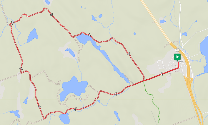
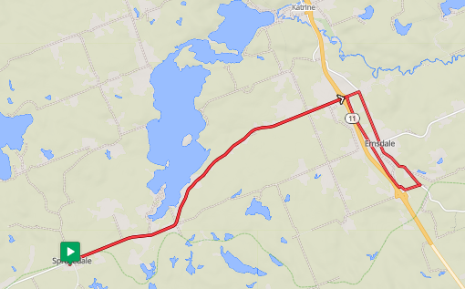
Doe Lake Loop - Gravel Cycling Route
a.k.a Doe Lake Me Far So La βeer Go
Distance: 40km Elevation: 530m Surface Type: Mainly gravel Difficulty: Moderate - mainly due to elevation density
View the route in RideWithGPS
Start options: Sprucdale, Katrine, Burk's Falls (off route) or Emsdale (off route)
Key features: Memorable climbs from Madill Road through to Star Lake Road mixed with great lake views. The route includes a crossing of HWY 518 and a portion of riding along HWY 518. HWY 518 has a paved should along this section and is regularly used by cyclists.
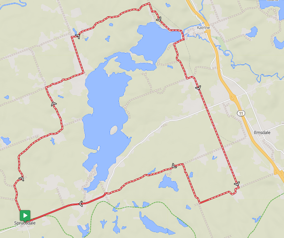
Snapshot of the Doe Lake Loop route map from RidewithGPS
Description:
A fun 40km route that showcases the finishing section of the Greystone Gravel Grinder and several memorable climbs. It also features some great lakeside views around Little Doe Lake, in Katrine.
The route passes Sprucedale and the beach portion of Katrine, with access to Emsdale or Burk’s Falls just off of the main route.
Parking options are available at the Community Center in Sprucedale (a.k.a McMurrich/Monteith) and at the Doe Lake Municipal Park in Katrine on Little Doe Lake. Kirk’s Gas in Sprucedale and the Katrine General Store in Katrine have ride drink and snack options (as well as post-ride drink options).
There is a public Bike Fixit Station at the beach in Katrine and map of road routes in the area.
Variation options:
Extend the route south to Fern Glen Road or farther to Old Novar Road back to Stisted and north to Sprucedale for a longer and more challenging ride. Shorten the ride and remove a significant climb by removing the Mason and Star Lake Road portion on the southern edge (extends potion along HWY 518).
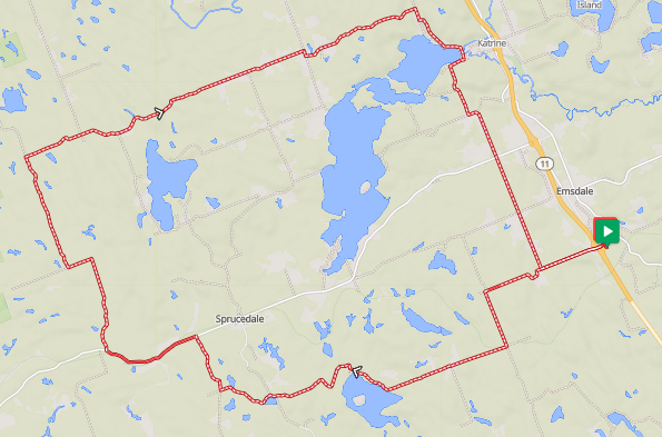
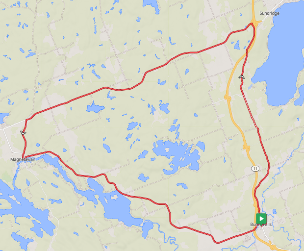
Pevensey & Rodeo Road Loop - Gravel Cycling Route
Distance: 52km Elevation: 540m Surface Type: Mainly gravel Difficulty: Moderate
View the route in RideWithGPS
Start options: Burk's Falls or Sundridge
Key features: Rodeo Road is a fun twisty roller-coaster section of the ride. This loop provides views towards Algonquin Park along Pevensey Road and very quickly transitions from towns to feeling like you are exploring the countryside.
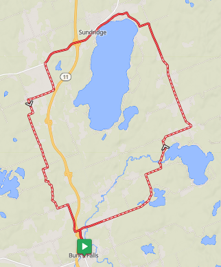
Snapshot of the route map from RidewithGPS
Description:
Lake Bernard has beach options on both sides. Checkerboard Beach, at the intersection of Pevensey Road and Lakeshore Drive is a nice stop just outside of Sundridge. Bernard's Bistro and Sips Craft Beverages are located along Main Street as places to stop for a drink or meal. The Waterfront Park in Sundridge has parking, charging station and covered area with picnic tables.
Foodland in Sundridge has a great selection and includes Zak's with health food, supplements and a different snack variety.
Nipissing Road Loop - Southern Section - Gravel Cycling Route
Distance: 71km Elevation: 770m Surface Type: Mixed - 2/3rds gravel Difficulty: Moderate - remote with no short-cut options & limited resupply options..but epic!
View the route in RideWithGPS
Start options: Sprucedale, Unserviced Parking Lot on HWY 518 - 1.5km west of Nipissing Road intersection, Magnetawan (off route)
Key features: Remote and uninterrupted scenic sections of gravel along historic roads. Nipissing Road is part of the suite of 'Colonization Roads' in the region with historic plaques along the way. Includes 20km of scenic and twisty HWY 518 along southern portion (paved).
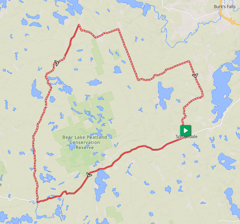
Description:
This is the core of our favourite route for showcasing the region. Even though it includes a stretch of secondary highway, the scenic and winding HWY 518 is still a great ride. In return, you get to experience the lakeside beachview at Bear Lake, the awesome Nipissing Road, Cornball Store (in Spence) and can sneak in the Screaming Heads, if you wish.
Variation options:
Add the Bear and Axe Lake loop on the southern end, off of HWY 518, for some extra gravel and distance.
Screaming Heads, along Midlothian Road, is just off this route but can be added as a quick out-and-back.
The Blackwater and Orange Valley Road loop provides an option starting from the western side of the region but only loops to the lower portion of the Nipissing Road section.
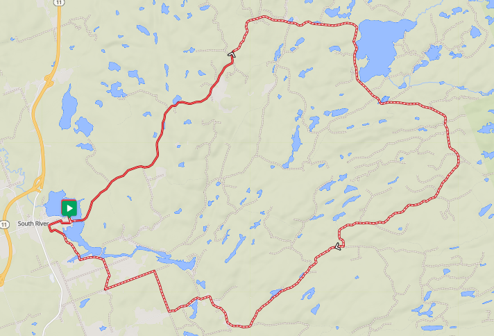
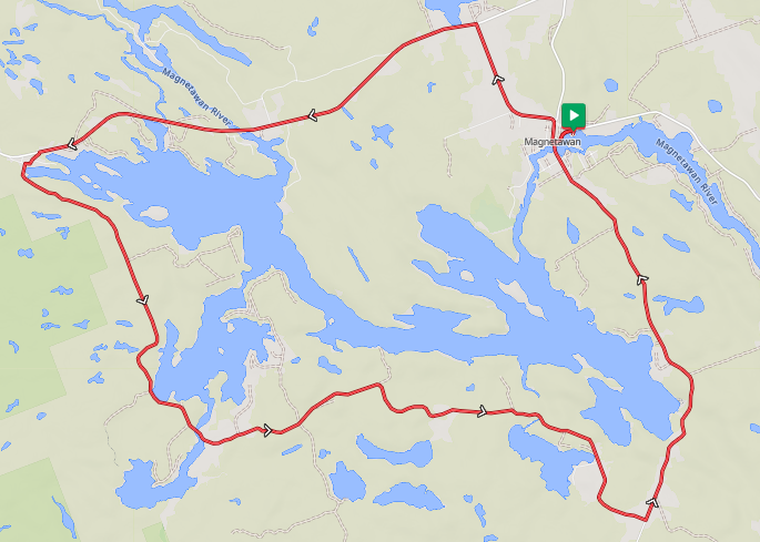
Nipissing Road Loop - Northern Section - Gravel Cycling Route
Distance: 84km Elevation: 850m Surface Type: Mainly gravel Difficulty: Moderate - remote with some technical
View the route in RideWithGPS (see notes regarding base layers and road names - toggle base layer to Google Maps)
Start options: Magnetawan, Mikisew PP or Eagle Lake (off route), South River (off route)
Key features: Like the Nipissing Road - Southern Section, this includes remote and uninterrupted scenic sections of gravel along historic roads. Nipissing Road is part of the suite of 'Colonization Roads' in the region with historic plaques along the way. This Northern Section includes portions of single-lane track with more technical riding.
Note that the RidewithGPS Cycle Map and Google Maps base layers do not agree/align on road naming in several sections of this route. When viewing in RidewithGPS, change the map base layer to Google Maps for best alignment with current road names. If following the GPS track, road names are not as relevant, but could still cause confusion if attempting to reconcile your GPS info with road signage.
"Old Nipissing Road Trail" (As labelled on Google Maps) (approx km 13 at the link provided) - from Youthdale Road to Pearcley/Center Road
"Pearcely Road" (RidewithGPS) vs "Center Road" (Google Maps)
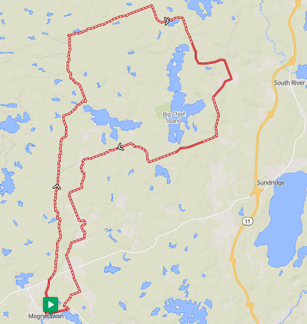
Variation options:
The option shown here is intended to maximize the Nipissing Road section, and starts/ends in Magnetawan. An alternative is the removing the 'tail' south to Magnetawan and completing the northern loop. Mikisew Provincial Park is located on Eagle Lake and is an optional starting point and parking is available at "the Narrows" on Eagle Lake.
Long Lake Road Loop - Gravel Cycling Route
Distance: 20km Elevation: 200m Surface Type: Gravel Difficulty: Easy-Moderate - a few climbs but a great shorter route option.
View the route in RideWithGPS
Start options: Novar (Firehall and Community Park)
Key features:
Fern Glen Road - Almaguin Gravel Sampler - Gravel Cycling Route
Distance: 60km Elevation: 750m Surface Type: Mainly gravel
Difficulty: Moderate - High - elevation ratio increase
View the route in RideWithGPS
Start options: Emsdale, Sprucedale, Katrine
Key features: A lumpy romp with Harrison Lake Road (single lane track) and the challenging finishing section of the Greystone Gravel Grinder (do not use this route file if participating in the event).
Description:
This is a hybrid of some of the routes featured in the Huntsville Mountain Bike Association (HMBA) fundraising event, the Greystone Gravel Grinder, which runs early May. We don't publish the exact event routes here as they may change year to year. They also utilize some sections that need to be verified as ready to ride early in the season. So, always utilize the route files provided by the HMBA. That said, this is a sampler of key sections from the multiple route options.
Variation options:
Numerous. This has a core portion to which many extensions can be added.
Blackwater & Orange Valley Road Loop - Gravel Cycling Route
Distance: 52km Elevation: 500m Surface Type: Mixed - 2/3rds gravel
Difficulty: Moderate - remote with no short-cut options & limited resupply options..but epic!
View the route in RideWithGPS
Start options: Orrville, Unserviced Parking Lot on HWY 518, Broadbent (Community parking lot on Blackwater just south of Hurdville Road)
Key features: Remote and uninterrupted scenic sections of gravel along historic roads. Nipissing Road is part of the suite of 'Colonization Roads' in the region with historic plaques along the way. Includes 20km of scenic and twisty HWY 518 along southern portion (paved).
If trying to map this route on your own, you'll likely notice a need to switch to manual mode to connect a section close to the Orange Valley Road and Nipissing Road intersections. (don't try and fix it - it keeps traffic down). For some reason, the map gods think it doesn't connect.
This is a great loop option for a shorter alternative to sample a portion of the Nipissing Road.
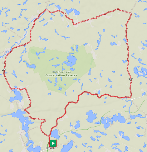
Variation options:
The default route here uses HWY 518 along the southern edge. An alternative, used by some brave souls during the Parry Sound Bikes Gravel Party, is to utilize the Seguin/Park2Park trail between Seguin Falls (just south of the Nipissing Road/HWY 518 intersection) and Orrville. While we have seen this done many times on gravel bikes...and the odd time on a road bike...this section is closer to MTB or 'Adventure Trail' as described above. While paved, the HWY 518 option is twisty and scenic, and most often used by local cyclists. Seriously consider your goals before jumping on the Seguin Trail as it may move your from 'great ride' into 'absolute slog' territory.
Chemical - Deadhorse - Paisley Road Loop - Gravel Cycling Route
Distance: 60km Elevation: 550m Surface Type: Mainly gravel
Difficulty: Moderate - remote with no short-cut options & limited resupply options.
View the route in RideWithGPS
Start options: South River
Key features: What a name, eh? The stuff marketers dreams or nightmares are made of. We keep the "Paisley" in the name to help offset the other parts. 🙂 Logging operations may be underway seasonally beyond Kawawaymog Lake. Strongly recommend a GPS with track loaded as there are numerous dead-end logging road off-shoots and cell reception can be spotty on the eastern edge of this loop.
The Almaguin Gravel Experience - Final Boss - Gravel Cycling Route
Distance: 182km Elevation: 1970m Surface Type: So much gravel Difficulty: High - a big day of lumpy remote riding
View the route in RideWithGPS
Start options: Sprucedale, Katrine, Burk's Falls, Sundridge, South River (off route)
Key features: One loop to touch the borders of the Almaguin Highlands. Ride Boundary road along the Muskoka divide before grinding your way north just shy of Loring-Resoutle and Commanda. Includes a significant portion of the Nipissing Road - North Section, if looking to demo a portion first.
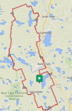
Description:
"Fuuuuuuuuuuuuuuuuhnnn." This brings a lot of the other routes together for a big day out exploring the region and has literally "all the gravels." We certainly use elements of this route during our retreat weekends, but not the full experience. This would be a possible option for our Base Builder or Unsatiated style weekends but be prepare for some fitness questions and to be self-sufficient.
Variation options:
If this isn't big enough you are into our Unsatiated route options. We recommend taking a bikepack-adjacent approach to this route to make sure you are fueled and have gear for a long day out.
This route stays committed to remote roads and passes through Burk's Falls and Magnetawan. Katrine, Novar and Sundridge or South River are accessible with minor detours.
East/West variations (escape plans) are likely obvious in map view, but if you start at the bottom, once you are at the top consider yourself committed.
It isn't always about gravel cycling
Routes for alternative disciplines:
Paved Routes:
We are updating our route information for 2026 - route details back up shortly!
AIM Triangle - Road Cycling Route
Distance: 62km Elevation: 614m Surface Type: Paved Difficulty: Moderate
View the route in RideWithGPS
Download the GPX file:
Sprucedale - Emsdale - Sprucedale - Paved Out-and-back & Loop
Distance: 35km Elevation: 320m Surface Type: Paved Difficulty: Easy-Moderate (Adjustable)
View the route in RideWithGPS
Download the GPX file:
Hwy 518 between Sprucedale and Hwy 11 has paved shoulders and more gradual rolling terrain compared to alternatives. Additional options include Katrine utilizing HWY 592, but add some sharp elevation.
Ahmic Lake Loop - Paved Cycling Route
Distance: 41km Elevation: 490m Surface Type: Paved Difficulty: Moderate (Punchy climbs)
View the route in RideWithGPS
Download the GPX file:
Bikepacking Routes:
Our Intro Bikepacking Weekend (BKPK WKND) is designed to be your gateway to an overnight adventure. Two days of gravel riding take us to Mikisew Provincial Park for a beautiful camp site. We provide gear transport so you carry only what you choose to.
Previous participants have used this as a way to go through the process of bikepacking. Organizing gear, following a route, sleeping in a tent, staying fueled and hydrated are challenging enough. It's okay to try ‘bikepacking’ without specific bags or carrying gear. We have also had experienced bikepackers use the weekend as a test run after returning from injury or surgery. They want time on the bike but need to ease back into carrying extra weight.
Route info to follow soon.
Note that the bikepacking options may include less traveled sections and a bit more opportunity for ‘adventure’.